Place Names of New Brunswick: Where is Home? New Brunswick Communities Past and Present
 Introduction |
  Alphabetical Listing |
  County Listing |
  Indexes |
  Definitions
 Skip Navigation Links
Located on the Quaco Bay in the Bay of Fundy, 4.53 km SW of
Bay View:
Saint Martins Parish,
St. John County: PO from 1844: in 1866 St. Martins was a farming and lumbering community with approximately 127 resident families: Hugh McQuislon, John Marr, James H. Moran and William Vail were shipbuilders: Edward Nugent was postmaster: in 1871 St. Martins had a population of 1,000: included Collina or East Quaco: in 1871 Collina had a population of 400: in 1898 St. Martins was a sub-port of entry, a station and terminus of the Hampton and St. Martins Railway with 1 post office, 30 stores, 4 hotels, 2 sawmills, 1 planing mill and woodworking factory, a manganese mine and mill, 2 lighthouses, 5 churches, and a population of 1,500: also included the community of Quaco West, located 3 km S of St. Martins: PO
Quaco 1835-1872: St. Martins was incorporated as a village in 1966.
Latitude
:
45° 21'
Longitude
:
65° 32'
County
:
St. John
Parish
:
Saint Martins
County location in province

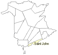 County map showing parishes
 Zoom in

Cadastral Maps
New Brunswick cadastral maps show the basic features of the province along with the boundaries, lot number, and grantee’s name for land granted by the province. These maps are cumulative, showing all grants regardless of date.
Zoom in

or
download
the full size version.
3760 x 2775 - 1.7 mb
|