Place Names of New Brunswick: Where is Home? New Brunswick Communities Past and Present
 Introduction |
  Alphabetical Listing |
  County Listing |
  Indexes |
  Definitions
 Skip Navigation Links
Located on W side of the Memramcook River, 2.26 km SW of
Upper Dorchester and 2.26 km SE of
Cormier Cove, on the road to
Rockland:
Dorchester Parish,
Westmorland County: PO 1853-1927 with Charles Taylor as first postmaster: in 1866 Taylor Village was a farming community with 25 resident families including the families of Alfred Taylor, Charles Taylor, David Taylor, George Taylor, George M. Taylor, James A. Taylor and Jonas Taylor: in 1871 it had a population of 100: in 1898 Taylor Village had 1 post office, 1 store, 1 church and a population of about 200: included the settlement of Rockland.
Latitude
:
45° 56'
Longitude
:
64° 33'
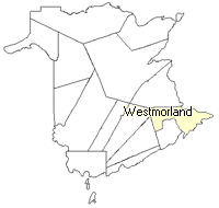
County
:
Westmorland
Parish
:
Dorchester
County location in province

 County map showing parishes
 Zoom in

Cadastral Maps
New Brunswick cadastral maps show the basic features of the province along with the boundaries, lot number, and grantee’s name for land granted by the province. These maps are cumulative, showing all grants regardless of date.
Zoom in

or
download
the full size version.
3760 x 2767 - 2.4 mb
|