Place Names of New Brunswick: Where is Home? New Brunswick Communities Past and Present
 Introduction |
  Alphabetical Listing |
  County Listing |
  Indexes |
  Definitions
 Skip Navigation Links
Located on the Northumberland Strait, 3.85 km E of
Cap-Pelé and 4.27 km WNW of
Petit-Cap:
Botsford Parish,
Westmorland County: first called Léger Brook: PO 1894-1957 with A.F. Léger as the first postmaster: in 1898 Léger Brook was a farming and fishing settlement with 1 post office, 1 lumber mill, 3 lobster factories and a population of 150: became part of
Beaubassin East in 2006.
Latitude
:
46° 13'
Longitude
:
64° 13'
County
:
Westmorland
Parish
:
Botsford
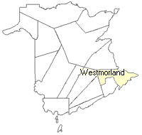
County location in province

 County map showing parishes
 Zoom in

Cadastral Maps
New Brunswick cadastral maps show the basic features of the province along with the boundaries, lot number, and grantee’s name for land granted by the province. These maps are cumulative, showing all grants regardless of date.
Zoom in

or
download
the full size version.
3676 x 2881 - 2 mb
|