Place Names of New Brunswick: Where is Home? New Brunswick Communities Past and Present
 Introduction |
  Alphabetical Listing |
  County Listing |
  Indexes |
  Definitions
 Skip Navigation Links
Located 8.61 km ESE of
Geary, on the road to
Clones, about 1.5 km W of the Burton/
Gagetown parish boundary:
Burton Parish,
Sunbury County: established in 1836: in 1866 Victoria Settlement was a farming community with about 15 families: in 1871 it had a population of about 150: PO 1882-1888: in 1898 Victoria Settlement had 1 post office and a population of 50: Victoria Settlement is no longer a community as it was located within the area expropriated for
CFB Gagetown.
Latitude
:
45° 44'
Longitude
:
66° 23'
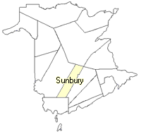
County
:
Sunbury
Parish
:
Burton
County location in province

 County map showing parishes
 Zoom in

Cadastral Maps
New Brunswick cadastral maps show the basic features of the province along with the boundaries, lot number, and grantee’s name for land granted by the province. These maps are cumulative, showing all grants regardless of date.
Zoom in

or
download
the full size version.
3615 x 2773 - 1.5 mb
|