Place Names of New Brunswick: Where is Home? New Brunswick Communities Past and Present
 Introduction |
  Alphabetical Listing |
  County Listing |
  Indexes |
  Definitions
 Skip Navigation Links
Located 1.28 km E of
Cocagne Cove and 1.85 km S of
Bourgeois:
Dundas Parish,
Kent County: named for an Acadian family descended from Roger Kuessey (Sasey, Caissy, Quessy) originally from Ireland, who was a settler of the Chignecto area in the 1600s: area grantees were Acadian settlers Belony Caissie, Philip Caissie, Urban Caissie, Francis Caissie and Gabriel Caissie: PO 1931-1955: in 1898 Caissie Cape was a farming and fishing settlement with 1 lobster factory and a population of 200.
Latitude
:
46° 20'
Longitude
:
64° 32'
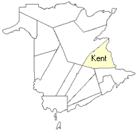
County
:
Kent
Parish
:
Dundas
County location in province

 County map showing parishes
 Zoom in

Cadastral Maps
New Brunswick cadastral maps show the basic features of the province along with the boundaries, lot number, and grantee’s name for land granted by the province. These maps are cumulative, showing all grants regardless of date.
Zoom in

or
download
the full size version.
3616 x 2749 - 2.1 mb
|