Place Names of New Brunswick: Where is Home? New Brunswick Communities Past and Present
 Introduction |
  Alphabetical Listing |
  County Listing |
  Indexes |
  Definitions
 Skip Navigation Links
Located near the mouth of the Magaguadavic River, 6.42 km SW of
St. George, on the road to
Letete:
Saint George Parish,
Charlotte County: settled in 1822: named for John Mascarene, who received a large grant of land nearby: PO 1860-1944: in 1866 Mascarene was a farming and fishing settlement with about 26 families: in 1871 it had a population of 200: in 1904 Mascarene had 1 post office, 2 stores, 1 sardine factory, 1 church, 1 lighthouse and a population of about 150.
Latitude
:
45° 6'
Longitude
:
66° 54'
County
:
Charlotte
Parish
:
Saint George
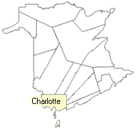
County location in province

 County map showing parishes
 Zoom in

Cadastral Maps
New Brunswick cadastral maps show the basic features of the province along with the boundaries, lot number, and grantee’s name for land granted by the province. These maps are cumulative, showing all grants regardless of date.
Zoom in

or
download
the full size version.
2750 x 3903 - 2.9 mb
|