Place Names of New Brunswick: Where is Home? New Brunswick Communities Past and Present
 Introduction |
  Alphabetical Listing |
  County Listing |
  Indexes |
  Definitions
 Skip Navigation Links
Located on W side of the Petitcodiac River, 2.26 km SW of
Gunningsville, across from
Moncton:
Coverdale Parish,
Albert County: PO
Riverview 1876-1905 and 1907-1930: in 1898 Riverview was a farming settlement with 1 post office, 1 store, 1 sawmill, 2 churches and a population of 80: included the community of
Middle Coverdale: PO
Middle Coverdale 1861-1919: Riverview was incorporated as a town in 1974 as a result of the the amalgamation of the communities of Riverview,
Bridgedale,
Gunningsville, and
Riverview Heights.
Latitude
:
46° 3'
Longitude
:
64° 48'
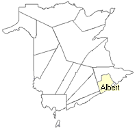
County
:
Albert
Parish
:
Coverdale
County location in province

 County map showing parishes
 Zoom in

Cadastral Maps
New Brunswick cadastral maps show the basic features of the province along with the boundaries, lot number, and grantee’s name for land granted by the province. These maps are cumulative, showing all grants regardless of date.
Zoom in

or
download
the full size version.
3650 x 2713 - 2.6 mb
|