Place Names of New Brunswick: Where is Home? New Brunswick Communities Past and Present
 Introduction |
  Alphabetical Listing |
  County Listing |
  Indexes |
  Definitions
 Skip Navigation Links
Located 10.95 km WNW of
Scotch Settlement, on the road to
Upper Caverhill:
Queensbury Parish,
York County: settled in 1842: PO 1864-1914: in 1866 Springfield was a farming community with approximately 30 resident families: in 1898 Springfield had 1 post office, 1 store, 1 church and a population of 250: included the settlement of
Upper Springfield.
Latitude
:
46° 1'
Longitude
:
67° 4'
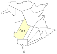
County
:
York
Parish
:
Queensbury
County location in province

 County map showing parishes
 Zoom in

Cadastral Maps
New Brunswick cadastral maps show the basic features of the province along with the boundaries, lot number, and grantee’s name for land granted by the province. These maps are cumulative, showing all grants regardless of date.
Zoom in

or
download
the full size version.
3688 x 2739 - 2 mb
|