Place Names of New Brunswick: Where is Home? New Brunswick Communities Past and Present
 Introduction |
  Alphabetical Listing |
  County Listing |
  Indexes |
  Definitions
 Skip Navigation Links
Located on the Shepody Bay, 4.3 km WSW of
Hopewell Hill:
Hopewell Parish,
Albert County: included the community of Hopewell Corner: PO
Hopewell Corner 1854-1875: also included River Side: PO 1867-1932: in 1871 River Side had a population of 50: in 1904 "River Side" was a station on the Salisbury and Hillsborough Railway and a community with 1 post office, 3 stores, 1 drug store, 1 hotel, 1 planing mill, 1 sawmill, 1 carriage shop, 1 carding mill, 1 church and a population of 300: PO
Albert from c1875: PO
Riverside from 1932: Riverside-Albert was incorporated as a village in 1966.
Latitude
:
45° 45'
Longitude
:
64° 44'
County
:
Albert
Parish
:
Hopewell
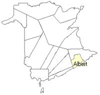
County location in province

 County map showing parishes
 Zoom in

Cadastral Maps
New Brunswick cadastral maps show the basic features of the province along with the boundaries, lot number, and grantee’s name for land granted by the province. These maps are cumulative, showing all grants regardless of date.
Zoom in

or
download
the full size version.
2805 x 3861 - 1.9 mb
|