Place Names of New Brunswick: Where is Home? New Brunswick Communities Past and Present
 Introduction |
  Alphabetical Listing |
  County Listing |
  Indexes |
  Definitions
 Skip Navigation Links
Located on W side of
South Bay, 6.8 km SE of
Grand Bay and 8.05 WSW of
Saint John:
Lancaster Parish,
St. John County: possibly named for a ship of the spring fleet of 1783 that brought 212 Loyalists to
Saint John: Aurora became part of South Bay: now within the city of
Saint John.
Latitude
:
45° 15'
Longitude
:
66° 9'
County
:
St. John
Parish
:
Lancaster
County location in province

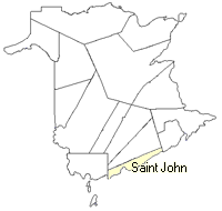 County map showing parishes
 Zoom in

Cadastral Maps
New Brunswick cadastral maps show the basic features of the province along with the boundaries, lot number, and grantee’s name for land granted by the province. These maps are cumulative, showing all grants regardless of date.
Zoom in

or
download
the full size version.
4912 x 3485 - 3.5 mb
|