Place Names of New Brunswick: Where is Home? New Brunswick Communities Past and Present
 Introduction |
  Alphabetical Listing |
  County Listing |
  Indexes |
  Definitions
 Skip Navigation Links
Island located in the Bay of Fundy SE of
Campobello Island:
Grand Manan Parish,
Charlotte County: Ganong identified the name for Grand Manan as
Munasnook': in 1866 there were a number of fishing settlements on the island with approximately 238 resident families: a list of the communities and the number of resident families in 1866 follows:
Fry's Mill, 4;
Grand Harbour, 31;
Great Duck Island, 3;
High Duck Island, 3;
Long Island, 5;
Mark Hill, 12;
Nantucket Island, 2;
North Head, 86;
Ox Head, 2;
Ross Island, 8;
Seal Cove, 13;
Southern Head, 6;
Woodwards Cove, 43: PO
Grand Manan 1845-1902 was located on the northern part of the island: in 1871 the population of the entire island was 1,500: in 1898 Grand Manan was a port of entry, a fishing station and a community with 1 post office, 8 stores, 1 saw and box mill, several churches and a population of 800: the Village of Grand Manan was incorporated in 1995: included the communities of Grand Harbour, North Head, Woodwards Cove, Seal Cove,
Castalia, the rest of Grand Manan Island and surrounding islands of the Parish of Grand Manan with the exception of
White Head Island.
Latitude
:
44° 42'
Longitude
:
66° 47'
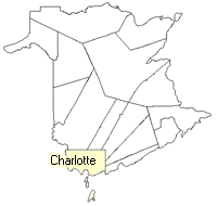
County
:
Charlotte
Parish
:
Grand Manan
County location in province

 County map showing parishes
 Zoom in

Cadastral Maps
New Brunswick cadastral maps show the basic features of the province along with the boundaries, lot number, and grantee’s name for land granted by the province. These maps are cumulative, showing all grants regardless of date.
Zoom in

or
download
the full size version.
2731 x 3830 - 1.5 mb
|